

Zenmuse L1
Instant Clarity. Superior Accuracy.
A Lidar + RGB Solution for Aerial Surveying
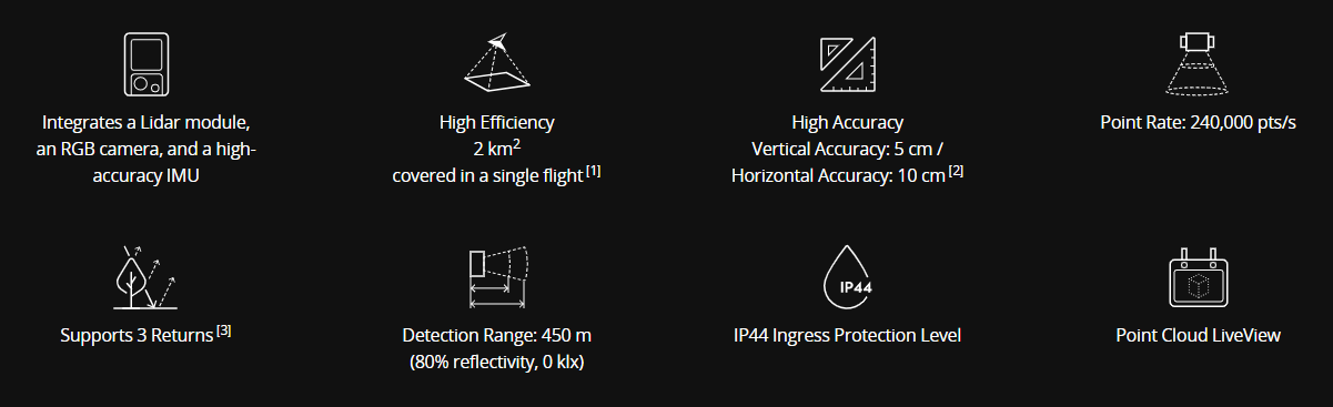
The Zenmuse L1 integrates a Livox Lidar module, a high-accuracy IMU, and a camera with a 1-inch CMOS on a 3-axis stabilized gimbal. When used with Matrice 300 RTK and DJI Terra, the L1 forms a complete solution that gives you real-time 3D data throughout the day, efficiently capturing the details of complex structures and delivering highly accurate reconstructed models.

DJI ZENMUSE L1 Technical Specifications
GENERAL
- Dimensions: 152x110x169 mm
- Weight: Approx. 900g
- Power: 30 W
- IP Rating: IP44
- Support Aircraft: Matrice 300 RTK
- Operating Temperature: -20° to 50° C (-4° to 122° F)
- Storage Temperature: -20° to 60° C (-4° to 140° F)
SYSTEM PERFORMANCE
- Detection Range:
450 m @ 80% reflectivity, 0 klx;
190 m @ 10% reflectivity, 100 klx - Point Rate:
Single return: 240,000 pts/s;
Multiple return: 480,000 pts/s - System Accuracy:
Horizontal: 10 cm @ 50 m;
Vertical: 5 cm @ 50 m - Real-time Point Cloud Coloring Modes:
True color; coloring by reflectivity; coloring by elevation
LiDAR
- Ranging Accuracy: 3 cm @ 100 m
- Maximum Returns Supported: 3
- Scan modes: Repetitive line scan mode, non-repetitive petal scan mode
- FOV:
Repetitive line scan: 70.4°×4.5°;
Non-repetitive scan: 70.4°×77.2° - Laser Safety: Class 1
INERTIA NAVIGATION SYSTEM
- IMU Update Frequency: 200 Hz
- Accelerometer: ±8 g
- Angular Velocity Meter Range: ±2000 dps
- Yaw Accuracy: Real-time: 0.18°, Post-processing: 0.08°
- Pitch/Roll Accuracy: Real-time: 0.03°, Post-processing: 0.025°
AUXILIARY POSITIONING VISION SENSOR
- Resolution: 1280×960
- FOV: 95°
RGB MAPPING CAMERA
- Sensor Size: 1 inch
- Effective Pixels: 20 MP
- Photo Size: 4864×3648 (4:3); 5472×3648 (3:2)
- Focal Length: 8.8 mm / 24 mm (Equivalent)
- Shutter Speed:
Mechanical Shutter Speed: 1/2000 – 8 s
Electronic Shutter Speed: 1/8000 – 8 s - ISO:
Video: 100 – 3200 (Auto), 100 – 6400 (Manual)
Photo: 100 – 3200 (Auto), 100 – 12800 (Manual) - Aperture Range: f/2.8 – f/11
GIMBAL
- Stabilized System: 3-axis (tilt, roll, pan)
- Angular Vibration Range: 0.01°
- Mount: Detachable DJI SKYPORT
- Mechanical Range:
Tilt: -120° to +30°; Pan: ±320° - Operation Modes: Follow/Free/Re-center
DATA STORAGE
- Raw Data Storage: Photo/IMU/Point cloud data storage
- Point Cloud Data Storage: Real-time modeling data storage
- Support microSD Cards:
microSD: Class 10 or UHS-1 rating or above; Max capacity: 256 GB
POST-PROCESSING SOFTWARE
- Supported Software: DJI Terra
- Data Format:
DJI Terra supports exporting standard format point cloud models:
Point cloud format: PNTS/LAS/PLY/PCD/S3MB format
Reconstruction model format: B3DM/OSGB/PLY/OBJ/S3MB format