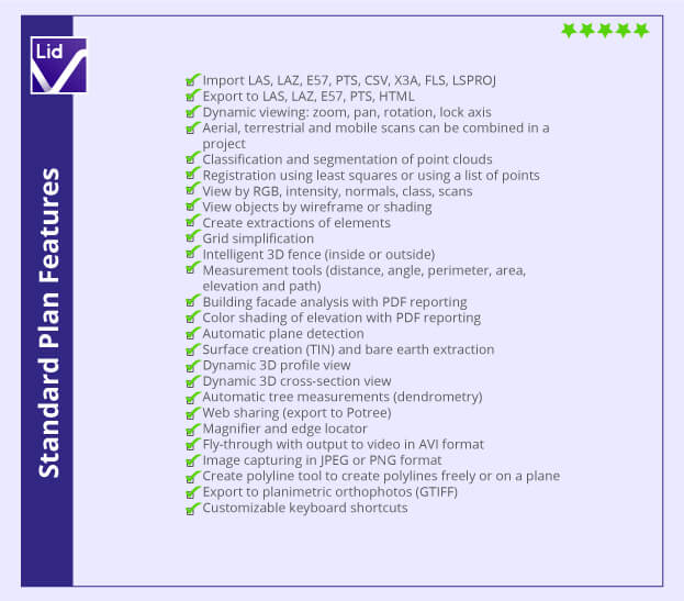
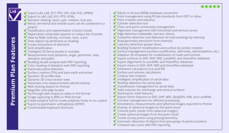
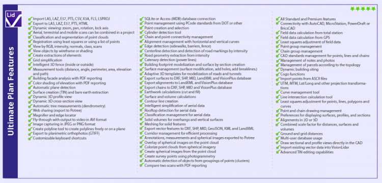
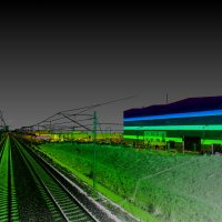
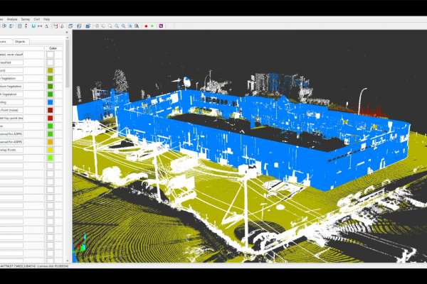
 VisionLiDAR is a complete standalone point cloud software, designed to simplify and automate work for LiDAR point cloud and 3D image processing in the air, on the ground and in motion. Import your data from any scanner and get qualitative and intelligent point cloud skimming, intelligent complex volume calculation with tetrahedrons (for overhangs) and many others. With VisionLiDAR, you now have a new and better way to acquire field data directly into your office. It offers many productivity and time saving tools like processing effectively over 100 billion points. Quickly and precisely calculate the volume between two surfaces, sections or complex volumes (overhangs), recognizing objects in a point cloud. Classify your points intelligently to avoid losing the original data. Its unique object classification method facilitates virtual land surveying. Accurately calculate the size and circumference of a pipe from a point cloud, making your land surveys from a vectorized point cloud. Process your land, mobile and air points with the same software and easily share your site surveys from the point cloud to your CAD and vice versa and many more. VisionLidar is the perfect partner for all your civil engineering, land surveying, architecture, BIM, transportation, mines, quarry, and forestry projects. VisionLidar comes in three versions to suit the needs of a wide range of clients: Standard, Premium, and Ultimate. Get a free quote and consultation now!
- Import module: import from txt, pts, ptx, E57, LAS, LAZ.
- Export module: export into LAS, LAZ, E57, PTS, LandXML, CSV, DXF.
- Registration: align scans independently from scanner software, add scans from aerial, terrestrial and mobile to an existing project, and reference entire projects to a coordinate system.
- Point Cloud Extract: Extract specific parts of the point cloud to classify, delete, or create surface.
- Classification: filter into 126 layers, with automatic detection of vegetation, building, and bare earth.
- Profile and Section: allows dynamic viewing of profile and section of your point cloud into any direction.
- Vectorize: create plans created based on your point cloud with points, line-works, alignment, surface directly into your CAD.
- Mesh: extract meshed digital 3D terrain models (DTM) on bare earth , without vegetation and building.
- Volume: create volume for complex overhang, and vertical surface.
- Dimensioning: measure and annotate angle, distance, area and volume.
- Plan intersection highlight: dynamic viewing of intersecting plans for easy selection.
- Vertical: Analyze the verticality of building with color distance interval.
- Adaptive template: detection of template from cross section, editing by interval, and export into dxf surface.
- Dendrometry: Tree trunk automatic detection, Tops, tree trunk, trunk height, crown, DBH (Diameter and Breast Height), Crown Surface measurements.
- Building footprints: Horizontal cross section allows to extract footprints into lines.
- Poles and lines: extract poles and power-lines.
- Intensity: extract any lines by point intensity for center-line road , railroad, and parking lots.
- Alignment 3D: extract lines and create 3D Alignment with horizontal curves, vertical curves, and spiral.